

I just returned from London last week where my colleagues Jeremy Knox and James Lamb, both of the University of Edinburgh, and I presented at the MODE: Methodological Explorations conference. James wrote a good blog post on our actual method (namely exploring EC1 on foot and documenting it along the way). The exercise in Ec1 on that day, parallel activity I have performed with my Finnish colleague Pekka, and some genealogical research I was doing the other day all dovetailed into this post, which hopefully makes sense towards the end.
Urban Flanerie and Multimodal Method
I suppose I am arguing that flanerie itself, that idea of the strolling/meandering urban explorer, is a privileged position. It is an exploration of a bounded geography, through the luxury of time and relative safety. It is a fruitful intersection of a time and space that comes off as serendipity, but might actually be more influenced by methodical and pragmatic considerations. It is, I believe, an extraordinarily fruitful method for charting/mapping space, one that inexorably makes visible theory that might have otherwise remained in the abstract. But first, the abstract for the presentation and subsequent paper was as follows:
In this paper, urban flanerie, adapted from Benjamin (2009), Shields (2006, 1994), and Hollevoet (1992), is defined as a means of urban exploration towards understanding the contemporary individual’s experience of urban space (Harvey, 2007). The flaneur is a participant observer, moving through urban space and exploring the semiotic exchanges, the socio-cultural structures, the processes, and materials that comprise urban life. According to Shields, he/she “ closes the gap between citizen and state, by re-imagining and mapping his newly expanded world” (1994); further, “the flâneur becomes a rhetorical strategy for rethinking the digital network activities and digital cartographies enabled by mobile technologies” (Kalin, 2009). It is this re-imagining, mapping, participant observer positioning, generative rhetorical strategy, and the subsequent multimodal artifacts generated as a result that we would like to propose as a method of great interest to research in multimodality.
In this methodological approach, individuals move through urban spaces with or without predefined learning objectives, collecting troves of multimodal data (audio, video, imagery, GPS data, text, etc.) based on emerging interests or curiosities. This data is then collected for individual multimodal compositions documenting or representing learning in urban space. This method draws on ethnographic work done in relation to flanerie (Guevara, 1997; Pin, 2008; Soukup, 2013) and advances urban flanerie as an auto-ethnographic method for research (adapted from O’Kane et al, 2014). The multimodal data and subsequent multimodal compositions generated from this urban flanerie can be transcribed using existing multimodal approaches (Kress & van Leeuwen, 2006) and analyzed as hybrid constructions of both urban and cognitive space.
Related projects involving urban flanerie as multimodal method were conducted by the researchers in Edinburgh (Lamb, 2014; Gallagher, 2014) in April, 2014, as well as in Helsinki, Finland (Gallagher, 2013) in May, 2013. To coincide with our attendance at the conference, the researchers will be undertaking an exeercise of this method in London, and would intend to showcase the method, the work, and the multimodal artifacts produced in conjunction with the paper presentation. These activities, both past and future, are discussed in this paper, along with their implications for education, recommendations for further methodological development, and further research. Urban flanerie presents considerable multidisciplinary value for research in multimodality, urban design, the humanities overall, and informal learning. It emphasizes space itself as an organizing material, a semiotic material in its own right. It embeds multimodal communication in situ and does so through commonly available mobile technologies. Ultimately, it reveals to both the learner and the researcher the semiotic dialogues taking place with individuals and their urban environments. As such, it has great value to both individuals lifelong learners, and educators looking to activate self-regulated learning outside the classroom.
It works as a learning approach. Any number of variations are possible. Just as we were bound by EC1, it is easy enough to bound the activity in a particular discipline (history, economics, psychology, etc). I have done this with students and it has proven fruitful in developing dialogue around a particular theme or concept.
Genealogy and Flanerie
In my daily routine, I find myself switching from my main research focus (mobile learning, open learning, etc.) into my secondary interests (history, literature) in order to maintain an enthusiasm or to freshen the mind a bit. I enjoy genealogical research partly because it is quite difficult to track my family name (Gallagher) past a certain point (stuck in 1858 in Brooklyn where my forebear entered the United States). Patrick Gallaghers in Brooklyn at that time were like (insert metaphor detailing copious amounts here). Either way, I am able to research those that married in to the Gallagher family. They were more literate, more land-owning, and more detail-oriented, all important elements in genealogical research.
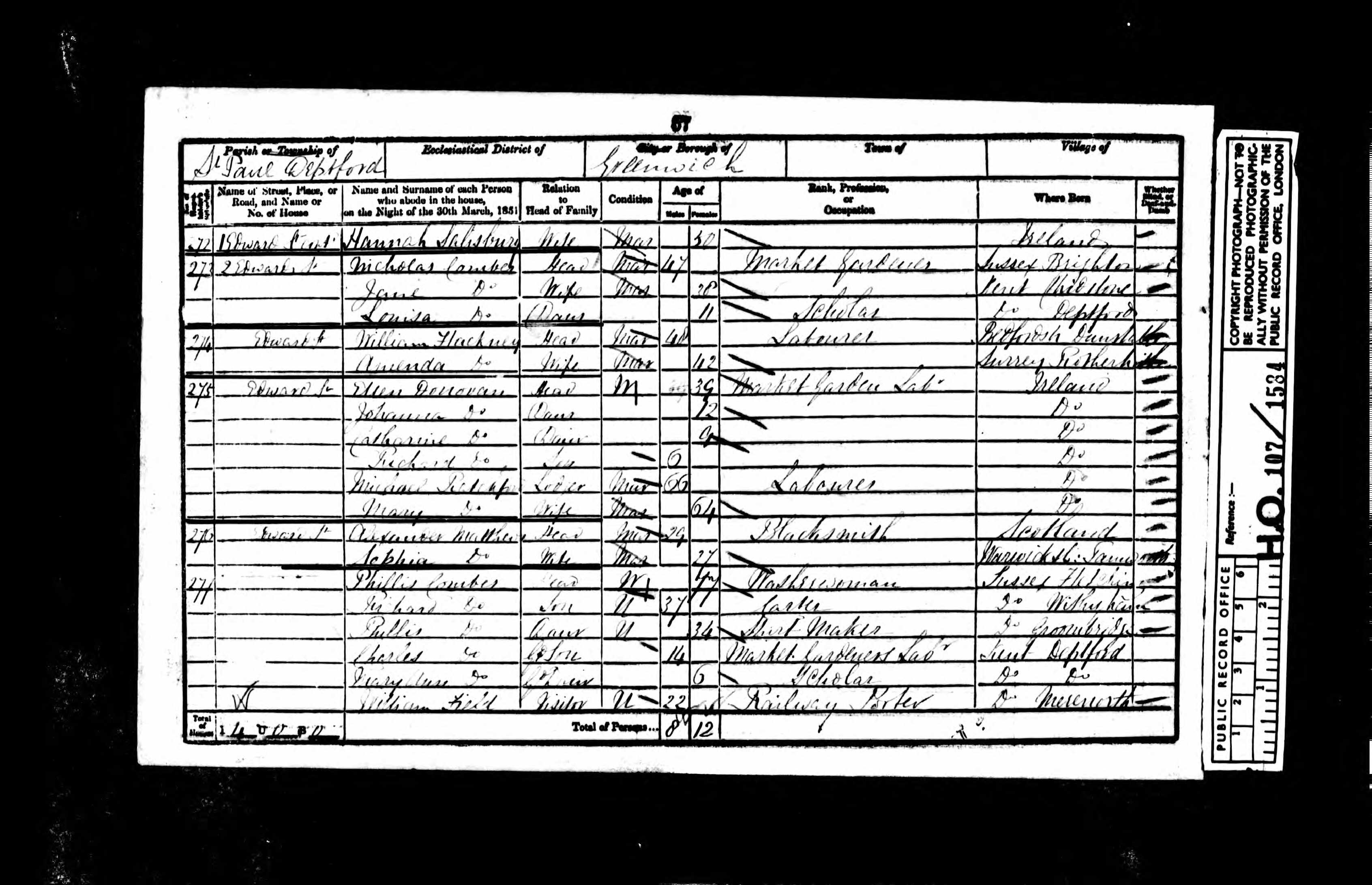
I have tracked my paternal great-great grandmother from Cork, Ireland to Deptford (just outside London at the time) in 1851. Her name is Catherine Donovan, aged 9, and she lived with her mother and siblings at 275 Edward Street, Deptford. Below is the census record to prove it. Single parent household. Mother is a market garden laborer (Deptford being famous at the time for its ‘gardens’, which were essentially small plots used to farm for food for either London’s larger markets, or for food for livestock). No father present. She eventually shows up again on the 1870 census in Philadelphia, married, with a few children.
To get a sense of the neighborhood both then and now, I turned to familiar sources: Google Maps’ Street View and Booth’s Poverty Maps (1886-1903). If you are unfamiliar with Booth’s Poverty Maps, they are exhaustive documentation (mapping) of London to chart the discrepancies between rich and poor. So 275 Edward Street can be mapped both then and now, as seen in the following image:

While these maps don’t make immediate, or urgent, the topographical or multimodal aspects of this terrain, it does suggest that they were very different places in these time frames. Deptford, while not gentrified by any stretch of the imagination, is presumably a bit more prosperous than it was for my distant forebear. St. Paul’s still stands as it stood for her. I have seen it. Yet I came there by choice. I came there with the resource of time and safety; I came with a way out. I came there as a literate, educated person with prospects. I walked down Edward Street not knowing that my forebear had played there as a young girl, just as I doubt she could have imagined some distant offspring of hers would ever want to come there to visit. Yet, our perspective on that space were radically different. I was a tourist; she a resident. Our experience of Deptford being radically shaped by the vagaries of time and space, of history and geography.
Flanerie as Socioeconomic and Historical Method
So this is where the socioeconomic aspects of flanerie enter the fray, where they might be positioned as a particular frame around the activity itself, just as EC1 bound our explorations. Using Booth’s Maps (the mobile version, cleverly titled Phone Booth), one can flaneur their way through the everyday, sorting through the detritus of the city, composing meaning from the manhole cover and the colonnade (paraphrasing my colleague James here), and then juxtaposing that meaning against another time/space reality, one from a relatively distant past, where time and safety were luxuries that not everyone was afforded.
I don’t see these time/space manifestations as binaries. Then and now. Poor vs. affluent. Privileged vs. not. This is a continuum of activity, the fluid narrative of space itself ebbing and flowing in response to the waves of people, activity, and social constructions affecting its composition. It repositions the architecture not as symbols of permanence or stability (or even just utility), but rather as constructs of human aspiration. What we want this to be, what we need this to be vs. what it is. The spire of St. Paul’s points up even as the socioeconomic conditions surrounding it, until a very recent time, would have laid low aspiration. Flanerie can support that juxtaposition, that tension.
Another case that I won’t belabor is Cross Bones, a beautiful space in Southwark. I happened to be staying at a flat right across the street and was curious to see all the ribbons attached to the gate of the park. I investigated and found out why. It is a cemetery and memorial park for paupers, for plague victims, for prostitutes. Coming full circle, the street it rests on is commented on in Booth’s Survey:
‘ …a set of courts and small streets which for number, viciousness, poverty and crowding, is unrivalled in anything I have hitherto seen in London.’
Now it is prosperous, expensive, and almost altogether gentrified. It is as if these people were never there, just as my great great grandmother might have never been in Deptford. But they were. And I am here, in my own time and space privileged reality, to testify. Flanerie presupposes that serendipity, that openness to experience, but also recognizes that all urban space is pregnant with this sort of possibility. We just have to look and enact our idiosyncratic methods for finding it.
To the ‘The Outcast Dead’ of Cross Bones, to the pauper children of Deptford, I honor you as a stranger, a visitor traveling in my orbits of learning. We all move within the bounds of our time and space, all of us.
Urban flanerie in #London as historical/socio-economic method: Deptford & Cross Bones. http://t.co/M0ybxhaap5 @james858499 @j_k_knox
RT @mseangallagher: Urban flanerie in #London as historical/socio-economic method: Deptford & Cross Bones. http://t.co/M0ybxhaap5 @james858…
RT @mseangallagher: Urban flanerie in #London as historical/socio-economic method: Deptford & Cross Bones. http://t.co/M0ybxhaap5 @james858…
RT @mseangallagher: Urban flanerie in #London as historical/socio-economic method: Deptford & Cross Bones. http://t.co/M0ybxhaap5 @james858…
Urban flanerie in #London as historical and socio-economic construct: Deptford and Cross Bones. https://t.co/FXiBOtA12q #mlearning
Booth’s Poverty Map, urban flanerie, history, & #London: Deptford & Cross Bones. https://t.co/lohNQ5dXi4 #mlearning https://t.co/FPReHlGSc6
[…] locations and with varying levels of ‘instructional’ control: in Edinburgh, in London, and now here in Bremen. Pekka and I have done similar activities in Helsinki and Seoul. All […]
Urban flanerie in #London as historical and socio-economic construct: #Deptford and Cross Bones… https://t.co/nmWNAKsSLZ