In a series of posts starting today, my colleague David Fox and I will discuss our efforts with an annotation project, one that should be seen as a companion piece to this paper on mLearning with Korean literature. We have been working for the past year to see if it were possible to take a literary text (or any historical text), georeference that text on an historical map of the same timeframe as the text, and then resolve that historical map with its modern equivalent to allow students to explore literary texts in the actual physical places that they describe. So basically to take a literary or historical text, map it accurately, and annotate it with both text and media. The trick is that the flow must be seamless: annotation to map, annotation to text, text to map. Ideally it would all happen through a mobile device.
These posts will be how on we went about this, what we learned, and what still needs to be done to make this a reality. We will talk about tools for cohering historical with modern maps, annotation standards, geocaching, and all sorts of things in between.
We should say at the onset that it is at least partly our hope that someone reads this and offers a suggestion of what we might do differently to get the desired results. So if you know of a better way, please do chime in with a comment.
First, though, a brief tour of the scenarios which we will pick up again later on. These were written from a utilitarian perspective, from a teacher’s perspective. Just a statement of what we want to do.
Scenario #1: Our goal is to experience a literary world within a physical and digital landscape. To take places that are described in our text and place them on a map of the physical world and then visit these places. We may then wish to write something about this place, or capture a photograph or video, or simply tell others, “I was here.” To consciously seek to live the literary text in its modern place.
Scenario #2: Our goal is to experience our modern worlds through a historical or literary lens. To walk the streets of our cities or towns, capture a photograph or video, and then add a literary text and a historical map to these recordings, to simply tell others, “Someone else was here.” We want to walk and document our worlds and add to them the texts of our past.
These scenarios on the surface span seemingly different terrain, but they are essentially the same. We want the literary or historical text, the map, and our annotations all in one place, on our phone, always present. That is our need as digital humanists, as teachers, students. And over the course of these blog posts, we will explore why this isn’t possible, and how it might be. We will discuss current initiatives in mapping and annotation, their limitations, and our requirements for a solution.
Rather than hint at it too much, we wanted to put the technical requirements out front to make it clear what we are after.
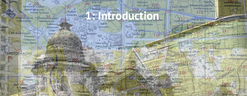
- As our text was written during a historical period not reflected on modern maps, it is useful to ‘georeference’ a historical map allowing users to locate places referenced in the text–places that may no longer exist or may now go by different names–in the real world.
- We should be able to link text and media annotations to locations on our map.
- Similarly, we should be able to link commentarial or binary annotations to locations in our text.
- It should be possible to associate a selection in our text to a location on our map and vice versa.
- Finally, following the familiar principles of geocaching, users in the field should be able to search this data and create new data using their own location.
So off we go. Expect one or two of these posts a week (as of now there are eight in total).
Annotation, #mLearning, & Geocaching Part #1: Scenarios & Technical Requirements https://t.co/hLKa3M1t16 @rexsavior https://t.co/0sLY2WyzUV
Scenarios and technical requirements for annotation, #mlearning, and geocaching https://t.co/DhaAXvsTkq #etech https://t.co/Bh6lQqpZg0
[…] Fox and I have been working to try to see what might be possible in this area (as discussed in the first part of this series of posts), so I will leave you with the use case itself that spurred all […]
[…] Annotation, mLearning, and Geocaching Part #1: Scenarios and Technical Requirements […]
[…] Annotation, mLearning, and Geocaching Part #1: Scenarios and Technical Requirements […]
[…] Annotation, mLearning, and Geocaching Part #1: Scenarios and Technical Requirements […]
[…] Annotation, mLearning, and Geocaching Part #1: Scenarios and Technical Requirements […]
[…] Annotation, mLearning, and Geocaching Part #1: Scenarios and Technical Requirements […]